
Flight and Airspace Information for Paragliders and Hang Gliders Pilots
Important information about the current version:
- In the event of starting problems, please activate the required authorizations manually in the Android app settings.
- Due to the current requirements for updating, it is unfortunately not possible for me to solve the current problems at short notice without completely revising the aged app. However, I see good chances of being able to offer a new version for the 2021 season.
GliderPal is aimed at paragliders and hanging conductor pilots. It allows access to information from the DHV flight area database and shows air spaces of Germany, Austria, France, Switzerland, Italy, Netherlands, Poland.
Please note that air spaces of some countries can be outdated (see data at skyfool.de)
Functions
• Access to DHV flight area database
• Access to air spaces from Germany, Austria, France, Switzerland, Italy, Netherlands, Poland
• Route planning with markings for FAI triangle
• Flight mode with display of position, flight lane, direction, speed, height, climbing
• Outdoor and air rooms available offline
• Reading database can be updated at any time by downloading
• Air spaces can be updated at any time by download
• Automatic data update
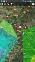
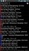
• Display flight area on card or in list form
• Card in road and satellite view
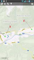
• Starting types slope, towed color -coded
• Display of the starting directions on card
• Display of the required slide between the start and landing site on card
• Search criteria: radius in km from the town, paraglider/hanging director, starting area, min. Height difference, starting type, access (car, on foot, public transport))
• Finding the terrain by criteria in the area
o of the current place
o of a place sought (place or terrain seed)
O of a place set on the map
• List list sorted by removal from the location including a kilometer information
• Calling phone numbers of the off -road contacts
• Call of off-road websites
• Calling the DHV site side
• Write emails to off -road contacts
• Navigate to start and landing sites via ext. App
• Display of all information from the terrain database
• Air rooms on the card colored by class
• Airspace information name, class, lower and upper limit
• Airspace lower and upper limit are also displayed converted in meters.
• Air space classes individually exchanged and fading
I tested the app for my possibilities. If there are any malfunctions of the app, please send me an error report before a bad rating and give me the opportunity to fix it. This also benefits the other users and leads to higher motivation with the author. Please keep in mind that the app is provided free of charge and ad -free,
Operating instructions: http://dandem-flug.net/gliderpal/ GliderPal _1.1_certienungsanung.pdf
By using the app, the user agrees with the DHV's terms of use for the
Ferien database too. This is available in the app via a link as a PDF.
The data for the air rooms were provided by the DFC Saar EV. Commercial use of the data is excluded from the provider of the data.
I do not guarantee the accuracy of the data from the DHV terrain database and the air spaces. Use of the data and the app at your own risk.
Data protection: No directly personal data is forwarded to me or third parties. The app uses Google Maps. To what extent data can be sent to Google here, please refer to their data protection regulations. Bugsense is used for quality assurance. In the event of crashes and download problems, I get information about the error, as well as hardware and software information. No personal data is collected here either.
 Download