• Home
  • Game
    Action Simulation RPG Sports Casual Cards Music Puzzle Shooting Romance
  • Apps
    Business Social Lifestyle Shopping Tools Travel Finance Education News Health
  • Blogs

English 中文(简体) 中文(繁体) 한국어 日本語 Português Español Русский العربية Indonesia Deutsch Français ภาษาไทย
Home Apps Tools PredictWind Offshore Weather
PredictWind Offshore Weather

PredictWind Offshore Weather

1
2
3
4
5
Download
  • Version 7.5.0.0
  • Category Tools
  • Package Name com.predictwind.offshore
  • Update Time March 28, 2025
  • Size 122.48MB
About this app

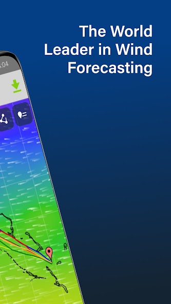
The Marine Weather App for getting GRIB files & viewing forecasts when offshore

The Offshore App allows you to seamlessly download multiple GRIB files for your coastal and offshore passages.

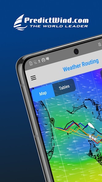
Quickly download and view GRIB files, weather routes, GMDSS maps and text forecasts, AIS data and satellite imagery.

Access all the world’s top ranking forecast models for reliable and accurate weather data, including ECMWF, SPIRE, UKMO, GFS and more. Our very own PWG & PWE models offer incredible accuracy and a record-breaking 1km resolution.

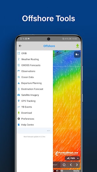
In addition to forecasts, the Offshore App also provides a suite of powerful marine tools to save you time and keep you safe at sea.

Weather Routing and Departure Planning is calculated in the PredictWind cloud at the highest resolution. The finished route is then sent back to your boat in an incredibly small file size, which is ideal for low bandwidth satellite and SSB connections.

The Offshore App works with Wi-Fi, mobile networks, and most satellite connections using an Iridium GO! exec, Iridium GO!, Globalstar or Optimizer device.

ADDITIONAL FEATURES

GRIB file viewer: High resolution forecasts maps with animated streamlines, wind barbs or arrows.

Tables: The ultimate dashboard for detailed analysis.

Graphs: Compare multiple parameters at the same time.

GMDSS Forecasts: View either in the traditional text format or on a map.

Destination Spot Forecast: Know exactly what the weather is doing at your destination.

Live Observations: Know what’s happening right now out on the water.

Ocean Data: See what’s happening under the waves with ocean and tidal currents, and sea temperature.

GPS Tracking: Get a free customised GPS tracking page for your blog or website.

AIS Data: View over 280,000 vessels worldwide on the AIS network.

What's New in the Latest Version 7.5.0.0

Last updated on Sep 7, 2024 Changes in v7.5.0.0:
. New map tool tip UI
. New source of Satellite Imagery to replace our old source that is no longer available.
. bugfixes
Download(122.48MB)
Users also viewed
  • Kustom LWP Komponent Pack

    Kustom LWP Komponent Pack

    1.0.1 January 17, 2026
  • EmWeatherIconsets

    EmWeatherIconsets

    1.0 January 17, 2026
  • Green Glow GO Locker Theme

    Green Glow GO Locker Theme

    1.0 January 16, 2026
  • Photo Jesus Live Wallpaper

    Photo Jesus Live Wallpaper

    1.02 January 15, 2026
  • 4K Video Live Wallpapers

    4K Video Live Wallpapers

    1.1.9 January 15, 2026
  • SD card cleanup tool

    SD card cleanup tool

    3.0.3 January 14, 2026
  • Zen Garden -Fall- LW

    Zen Garden -Fall- LW

    2.4 January 14, 2026
  • Craft Your Landscape

    Craft Your Landscape

    1.2.6 January 13, 2026
  • dCrawl

    dCrawl

    1.0 January 13, 2026
  • Permission Master

    Permission Master

    1.114 January 13, 2026
  • Brightest Torch Light - Flash

    Brightest Torch Light - Flash

    1.6.6 January 13, 2026
  • Simple XML Viewer

    Simple XML Viewer

    1.0 January 13, 2026
  • Hagel App

    Hagel App

    2.3.14 January 12, 2026
  • WebView Developer Browser

    WebView Developer Browser

    1.2 January 11, 2026
  • [test]screen touch

    [test]screen touch

    1.0 January 11, 2026
About Privacy Policy Terms of Service Cooking Policy

© Copyright 2017-2026 downzk.com