
Latest New mobile GIS app aiming at data collection for professional surveyors
A feature rich mobile GIS app aiming at data collection for professional surveyors
1st App to record attributes in custom menu
1st App to edit GIS data in complete off-line mode
Direct access to maps and update field data to Server GIS
Save at least 70% of work time than traditional data collection
Visit SuperSurv FB Fan Page for the most updated and exclusive information at https://www.facebook.com/SuperSurv
New features in SuperSurv Lite
- Support to label point, line, and polygon features
- Show GPS altitude on GPS status bar
- Enhance waypoint management
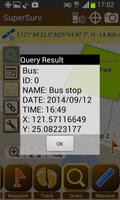
- Support Hyperlink function in Query tool
- Improve Query result window
Key features in SuperSurv :
1. Free base maps from OpenStreetMap
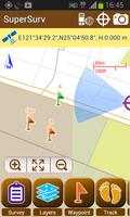
2. On-screen spatial query and measure tools
3. User-defined dropdown menu to input attributes
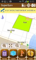
4. Geo-tagging to save XY info for surveyed targets
5. Collect features automatically or manually by real-time GPS
6. Export data and waypoints to be used in other GIS software
7. Offline data capture & edit (SHP/ GEO)
8. Various types of point, line and polygon symbols
9. Support global users with local coordinate systems
10. Connect and edit the map services published by SuperGIS Server
GISおよびGPSテクノロジーと統合すると、 SuperSurvにより、フィールド測量士はAndroidデバイスを使用してフィールドで空間データ(属性を含む)を効果的に収集および調査することができます。 The main functions of SuperSurv include data collection, orientation, map display, and direct interaction with Server GIS.
With the built-in GPS functions, the data of point, line and polygon can all be captured quickly. You may also create and manage waypoints with ease, and view waypoints in AR (Augmented Reality).
収集されたすべてのデータは、SuperGISデスクトップ3.2(http://www.supergeotek.com/productpage_sg3.aspx)など、デスクトップGISアプリケーションにエクスポートして適用できます。
The free version allows users to try the complete functions for 7 days. To continue experience the powerful GIS functions, please purchase the paid version--SuperSurv Pro.
Learn more about SuperSurv : http://www.supergeotek.com/productpage_SuperSurv.aspx?Type=Editions
 ダウンロード