

GPS ILS simulates an ILS approach using GPS data. 35,000 approaches included.
VFR flight ONLY!!!
(1) Voice vertical guidance into any airport. This helps flying consistent & safer short field VFR approaches into runways with no vertical guidance.
(2) "Flight Analysis" to review the approach precision and improve from feedback on every flight.
============================================================
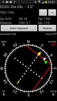
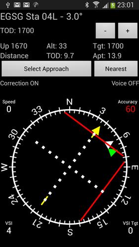
How does it work? (reference 1st App Screenshot)
* Connect Phone audio to headset, adjust audio volume
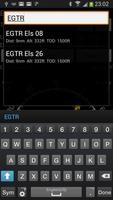
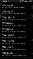
* Select desired approach
* Identify "Green Arrow" in HSI and turn aircraft to Top of Descent. (67 deg)
* Localizer bar is "red" indicating that loc is past the right limit.
* Localizer will turn "yellow" once in range
* "White Arrow" in HSI is the direction of touchdown point. (60 deg)
* "Yellow Arrow" in HSI is the direction of final approach course. (37 deg)
* Descent to "TOD altitude" (top of descent) using aircraft altimeter as reference
* Now a GREEN glide slope bar will appear and be centered
* As we approach the TOD and the synthetic ILS GP in "yellow" is coming down
* YELLOW ILS glide slope and the GREEN TOD glide slope will merge at TOD
* Passing the TOD turn to the final approach course shown as "yellow" arrow
* Descent with the YELLOW ILS glide slope
* Voice will announce: "50 up", "Center", "Down 100" etc....
* Menu: "Request Flight Analysis" after landing, suggest connecting via wifi
* Examples and details at: http://www.reuter-family.com/gpsils/GPSILS_Details.pdf. Thank You to Timothy Nathan
===============================================================
Watch the example video of on an actual ILS: www.youtube.com/watch?v=85AdUUd-kZw
We are approaching the localiser on a 125 heading and a TOD altitude of 1200ft. We are about 60 ft too low. The Green, White and Yellow arrows show the direction to the TOD point, the touchdown zone and the approach course respectively.
As the localizer comes in we turn to 207 for the intercept.
As we approach the TOD the Green and Yellow GP merge. The green arrow swings around to the left indicating that we pass TOD on the right.
The decent with the GP starts. The white arrow is now hidden behind the yellow arrow. The TOD is now behind us and hence the green arrow is pointing to our 6 o' clock position.
The voice announcement are suppressed. However you can see the announcements in the upper left of the phone screen. "Up 80" for example. The app shows an altitude of 510 ft at touchdown. According to the charts the runway is at 517 ft.
Once we pass the touchdown zone the white arrow moves to the 6 o'clock position.
Note, we used an external Bluetooth GPS on the glare shield with a 5 Hz update frequency. Any change in color of the "accuracy" field indicates a new GPS data point. CAUTION, usage of the internal phone GPS may materially reduce the accuracy.
http://www.youtube.com/watch?v=HqyAXyufBK8&feature=youtu.be shows a good match between GPS and ILS. At 1000 ft agl the tower switches the approach from circle to land to straight in. Compare the two glide slopes.
Further comparison of the app to an actual ILS: http://www.youtube.com/watch?v=TGLHkozNBRw
Courchevel with Audio announcement for altitude correction: www.youtube.com/watch?v=P__OlISD3xg
Scenic Courchevel (LFLJ) approach: www.youtube.com/watch?v=uNFNFZq2BFY
The app asks for the pilots e-mail address. The address is attached to log files and makes it possible to send comments back. Privacy is ensured. Upload/download of data may best be done when connected to internet via wifi. The data stays private.
To add more approaches drop me an e-mail or press the request button on the phone. 37,000 approaches can be down loaded via "Menu->Download Approaches".
Comments to: [email protected] Disclaimer: The software and data is as is. The author assumes no responsibility or liability either directly or indirectly.
Big "Thank You" to Mark Rae and Timothy Nathan who worked on improving the UI, database checks and test flights.






 Download